


Charleston
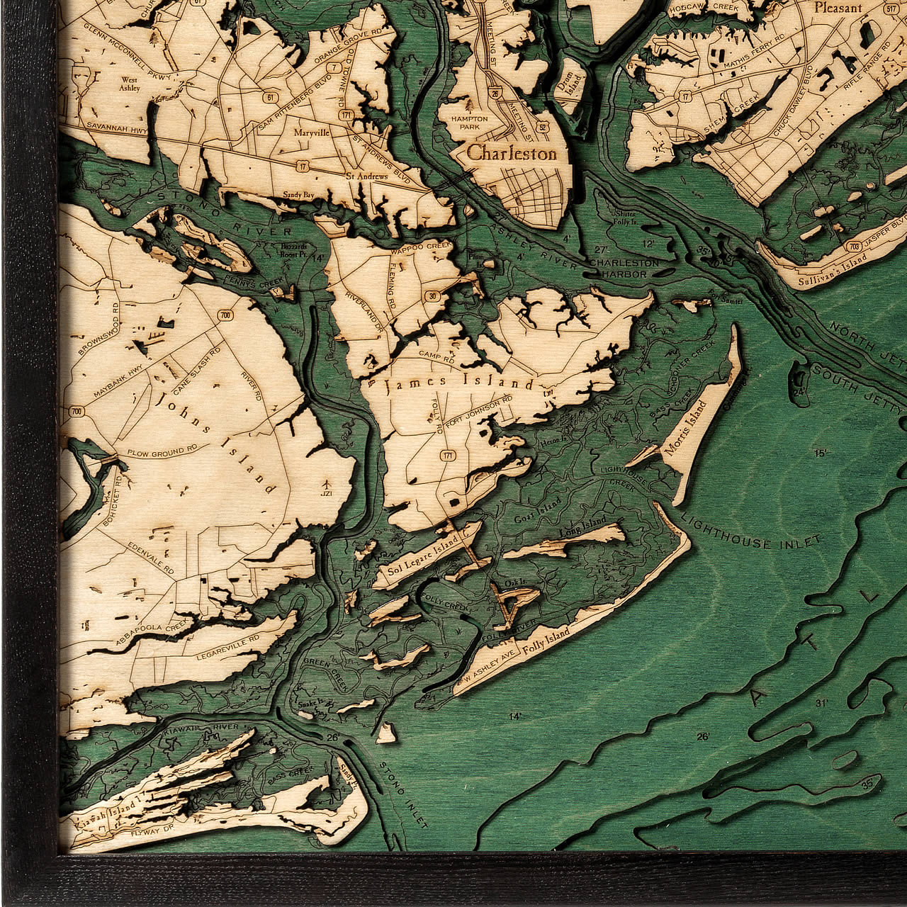
South Carolina’s oldest and largest city is Charleston. Lying along the coastline just south of the geographical midpoint with the Charleston Harbor it is bordered by the Atlantic Ocean inlet and the Ashley and Cooper rivers. This area is rich with American history and is known for its well-preserved architecture, mannerly people, high-end restaurants, and has received numerous accolades throughout the years, including Travel + Leisure’s recognition as America’s Most Friendly City. The climate is best described as humid and subtropical with hot summers, mild winters, and a significant amount of rainfall throughout the year. Charleston is made up of six distinct areas: downtown (also referred to as the peninsula), West Ashley, John’s Island, James Island, and the Cainhoy Peninsula. The Charleston Harbor runs roughly 7 miles long southeast to the Atlantic Ocean and averages widths of 2 miles—except the harbor’s entrance which is only about 1 mile wide. The north entrance includes Sullivan’s Island. Morris Island lies in the far southern region with water depths as far down as 18 feet.
- Abbapoola Creek
- Anderson Creek
- Ashley Phosphate Road
- Ashley River
- Atlantic Ocean
- Bass Creek
- Bees Ferry Road
- Bohicket Road
- Breach Inlet
- Brownswood Road
- Bull Breakers
- Bull Harbor
- Bull Island
- Bull Narrows
- Buzzards Roost Point
- Cainhoy Road
- Camp Road
- Cane Slash Road
- Capers Creek
- Capers Island
- Carolina Memorial Gardens
- Cat Island
- Charleston
- Charleston Harbor
- CHS Airport
- Chuck Dawley Blvd.
- Church Creek
- Clauson Creek
- Clements Ferry Road
- Clouter Creek
- Collins Park
- Cooper River
- Copahee Sound
- Cowhead Reach
- Cross County Road
- Cummings Point
- Daniel Island
- Darrell Creek
- Dewees Inlet
- Dewees Island
- Dorchester Road
- Drum Island
- Dutchman Island
- Eagle Island
- Edenvale Road
- Faison Road
- Fleming Road
- Flyway Drive
- Folly Creek
- Folly Island
- Folly River
- Folly Road
- Fort Johnson Road
- Fort Sumter
- Foster Creek Road
- Glen McConnell Parkway
- Goat Island
- Goose Creek
- Gray Bay
- Green Creek
- Halfway Creek Road
- Hamlin Sound
- Hampton Park
- Hanahan
- Heron Island
- Hickory Bay
- Hobcaw Creek
- Horlbeck Creek
- Isle of Palms
- Jack Primus Road
- James Island
- Jasper Blvd.
- Johns Island
- JZI Airport
- Kiawah Island
- Kiawah River
- Legareville Road
- Lighthouse Creek
- Long Island
- Long Point Road
- LRO Airport
- Mark Bay
- Mark Clark Expressway
- Maryville
- Mathis Ferry Road
- Maybank Road
- Meeting Street
- Morris Island
- Mount Pleasant
- N. Highway 17
- New Tenant Pond
- North Charleston
- North Jetty
- North Woods Park
- Nowell Creek
- Oak Island
- Old Fort Road
- Orange Grove Road
- Ordinance Ave.
- Palm Blvd.
- Palmetto Drive
- Paradise Island
- Park West Blvd.
- Pennys Creek
- Pepperhill Park
- Pine Island
- Plow Ground Road
- Plum Island
- Point Hope Island
- Porcher Bluff
- Price Inlet
- Rattlesnake Shoal
- Remount Road
- Rifle Range Road
- River Road
- Riverland Drive
- Rivers Ave.
- S. Aviation Ave.
- Sam Rittenberg Blvd.
- Sandy Bay
- Santee Pass
- Savannah Highway
- Schooner Creek
- Seewee Bay
- Seewee Road
- Shem Creek
- Shipyard Creek
- Shutes Folly Island
- Snake Island
- Sol Legare Island
- South Carolina
- South Jetty
- Spruill Road
- St. Andrews
- St. Andrews Blvd.
- Stono Inlet
- Stono River
- Sullivan's Island
- Thomas Island
- Toomer Creek
- Wagner Creek
- Wando River
- Wappoo Creek
- West Ashley
- West Ashley Ave.
- Whitehall Terrence
- Yeamans Hall Road
- Yellow House Creek


